Bude to Crackington Haven
- Aug 10, 2025
- 4 min read
August 9, 2025 - from the itinerary: Rated as challenging/strenuous. An easy start on the grassy cliff path along the back of the beaches from Bude to Widemouth Bay should not mislead you into imagining the whole day will be like this. The Path soon proves challenging as it becomes rough and narrow in places and plunges into steep valleys, including Scrade which is one of the deepest and steepest valleys on the Cornwall section of the Coast Path. This walk provides you with wide, open views of the Atlantic from high cliff top paths where you are always conscious of the force of the sea and winds due to the uneven ground and crumbling cliffs below you.
Distance: 10.91 miles. Weather - overcast and warm. No rain expected


In summary: amazing weather and felt harder than the 2 days before. There still weren't many hikers, except around the Widemouth area.
Each night I do some laundry and hope for a towel rack that actually does heat up. This one was disappointing:(


Breakfast was rather vinegary tasting - they added a bit too much when poaching. The sausage was good though....


Below are my comments on all of the "must-see" items from the guidebook:
The 1830’s octagonal Storm Tower on Compass Point, also known as the Tower of the Winds, was rebuilt in the 1880’s matching the Temple of the Winds in Athens. Here is also a view back towards Bude - if you look closely, you can see the tide is out and the boats are all beached.


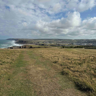
Watching the surfers from Efford Beacon. On a clear day it is even possible to see some of the inland tors of Dartmoor.


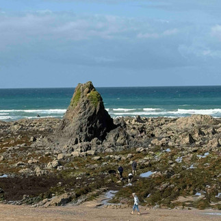
Spotting grey seals from the magnificent cliffs at Phillip’s Point Nature Reserve, with views north to Hartland Point and south to Widemouth Bay. Sea campion and pink thrift grow in abundance here. There were no seals today....
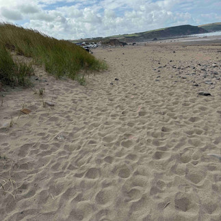
Searching for marine wildlife in the many rockpools of Widemouth Bay. I would have liked to skip the Widemouth area, but no such luck. A lot of very white British tourists frolicking in the surf and the worst kind of hiking - through sand. One exception was seeing this wonderful Newfoundland hound who had booties on. I also saw a sailboat going by


The folded, contorted strata of Millook Cliffs are of national importance. They can be appreciated better from the beach below. This folding was very interesting - it looked like layers of lava. In fact it's caused by the tectonic plates, according to the museum in Bude. You can't see it very well in this photo
Spotting the many butterflies in the steep stream valleys. The local name for Chipman Valley is actually Butterfly Valley due to the many red admirals, pearl-bordered fritillaries, ringlets and meadow browns found here. Unfortunately I didn't see any of these.


Looking down on Dizzard Wood’s sessile oak trees which are stunted by the force of the Atlantic winds.


This stretch of coastal woodland is of international biological importance for the many rare lichens and mosses which enjoy the exceptionally clean air of the North Cornwall coast.


Dizzard Wood is actually said to be a remnant from the prehistoric wood that once covered the entire country. This area was wonderful and the trees were very interesting and not much taller than 6 feet (not including the crown). There is a documentary about these trees, according to the local fellow who pointed them out to me.
Tremendous views from Castle Point. Yes, they were very good and included in the below video.


The many waterfalls, including the final one at Aller Shoot. I didn't see any waterfalls - it's been very dry.
After Aller Shoot was The Scrade. This was almost the final combe for the day and it ended me. These pictures don't do it justice. The first is the downhill, the last is the uphill.


Worse - I thought Crackington Haven was just on the other side, but there was another combe just afterward - thankfully not as bad as Scrade, but I was done in.
The fantastic views from Pencannow Point to Hartland Point, Tintagel and out to Lundy Island. In the summer, the valley below becomes ablaze with colour from masses of heathers and gorse. In the below video you can see the heather along the path. Yes - these are included in the below video. The photo on the left shows 500 miles to Poole - the end of the Path. In the middle is the last marker before getting to the view. The next photo is the bay.


This is very hard to see in this picture, but the cliffs are continually eroding. Sometimes gently, like in the photo, and sometimes in a very dramatic way.


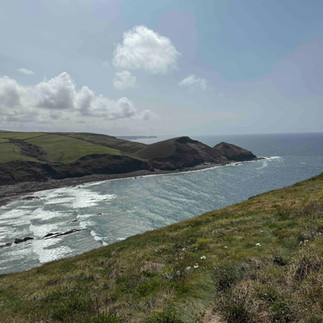
This was my lunchtime view

Along the way I realized it's time for new gloves.
I stayed at the Combe Barton Inn which is a pub right on the beach.


Immediately after arriving Buni and I had a beer and a view


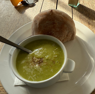
It was a lovely dinner of soup and salad, but very expensive. Hard to see through the window, but the sea was very rough.


Here are some views from the day, set to British folk music


Very nice views and hard walking....but......where is Buni!!!