Sennen Cove to Lamorna
- Aug 24, 2025
- 8 min read
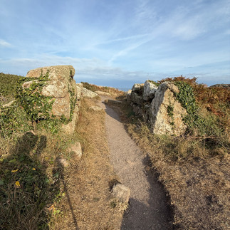
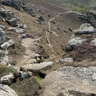
August 23, 2025 from the Itinerary: Difficulty rating: Challenging - Moderate to Strenuous (whatelse is new?). This section is undulating but mostly good underfoot. The strenuous rating is for the last mile appoaching Lamorna, where the Coast Path negotiates its way through a jumble of granite boulders, and so care is needed to pick your way.
This particularly beautiful section of Coast Path certainly feels like it begins at the very edge of the land, as the Path leads you along high cliffs and exposed, windswept heath. Once past the Land’s End complex, forget the tourists and enjoy the rugged peace and seclusion of the South Cornwall coast. There is much to see here, so do allow plenty of time.
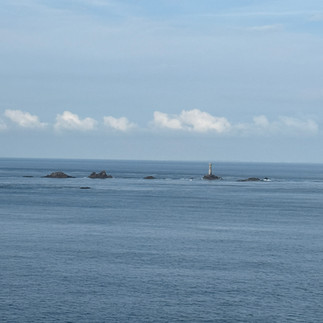
On a clear day, there are fantastic views across the sea out to Wolf Rock Lighthouse and the Isles of Scilly. Birds such as fulmars, shags, rock pipits and occasional peregrine falcons can be seen along this stretch and the incredible geological formations, including offshore rock stacks and rippling cliffs, as well as the natural land-bridge of Tol-Pedn-Penwith at Gwennap Head, add to the sheer drama of the landscape, undoubtedly some of the best of the entire Coast Path.
Distance: 13.37 Weather: 70s and sunny.


Highlights:
The rocky islet known as The Irish Lady: this offshore rock is named after the sole survivor of a wreck, who was seen clinging to the rock but drowned before help could reach her. Fishermen still report sightings of a lady perched on the rocks with a rose in her mouth!
Not sure exactly where this was....and didn't see a lady on any rocks
Maen Castle: dating from around 500BC, this Iron Age fort is one of the oldest cliff castles in Cornwall and has two visible ditches across the neck of the headland
I did see this castle, or what was left of it - not a lot now, but there is a bit more in the video. Here's the entrance

The exhilarating feeling of standing on Land’s End and looking out to sea. You may spot dolphins or basking sharks from here.
Amazingly Lands End was empty when I was there and a nice local fellow offered to take my picture. Here I am today at Land's End and in 2018 at John O'Groats at the other end of Britain. Also here's a shot of the "First and Last House"


It was clear enough to see the Scilly Islands - just visible in the distance.


The Wildlife Discovery Centre at Land’s End, which is staffed by the RSPB during the summer months and has telescopes to help you identify the seabirds and wildlife. Entrance is free, open from Easter to October, 10.00-17.00, Sunday to Thursday.
It's Saturday, so missed this
Watching the seabirds around the Armed Knight and the stunning Enys Dodnan - an offshore stone arch best appreciated when looking back at it.


The view to the Longships Lighthouse, a mile west of Land’s End. Once manned by four men who had to deal with raging seas swamping the lantern, it was replaced in 1875 by a 35 metre tower and eventually automated in 1988. They were paid £30/year.
National Coastguard Institution - Gwennap Head: a cliff castle once stood here and now it is the site of a National Coastwatch Station, undoubtedly due to the fact that this headland provides an extensive view of the rocky coast and busy shipping route. There are also navigation markers on the headland to warn ships of the rock pinnacle known as The Runnel Stone (or Rundle Stone) which is situated about a mile south of Gwennap Head and has been responsible for several wrecks. This area is popular with bird watchers and the granite cliffs make it ideal for climbers.

This is where I stopped when my right boot (Lumpa) started to rub a blister because the inside rip started to rub. It was at the 5 mile mark. I guess I'm going to have to give up on these boots next year. While I was stopped I did see two sets of climbers. Off shore is another lighthouse to warn boats. Even though it was a bank holiday weekend, there were some drills going on. A very noisy helicopter was quite close in - this is in the video below.


St Levan Holy Well: a pre-Christian holy well. The clear water is still sometimes used for baptisms and was once believed to cure eye and tooth problems.
The water looked pretty scummy, so didn't try it.


Resting on the secluded sands of Porth Chapel Beach.
No resting for me. I was tired of all the other people trying to find this beach and asking me where it was.
The stunning location of the world famous open-air Minack Theatre carved into the rock.
Way too crowded/dangerous with many people walking down steep stone stairs. Didn't actually see the inside of the theater because they wanted £14 just to look inside. I did get a shot from across the bay. It was a lovely setting, but too many people.


Logan Rock headland and stone: the Logan Rock is an eighty ton granite boulder on the edge of the cliffs south of Treen. It used to easily rock back and forth if pressure was applied in the correct place, however a group of sailors under Lieutenant Goldsmith dislodged it in 1824 and it fell crashing to the sea below. After much outcry from the locals, the sailors were ordered to replace it at their own cost, which took nearly seven months. The bills for the work and drawings of the procedure can be seen in the Logan Rock Inn in Treen.
Not sure I actually saw this, but it's an interesting story and I think this might have been it


The beautifully unspoilt Penberth Cove, which still has a small fishing fleet.
They had an interesting wench system to pull the boats out of the Bay which doesn't come through too well in the photo. A capstan and heavy chain were involved.


The lush, exotic woods around St Loy.
I think this was a bit oversold, but it was a rather nice area with some streams. The path was degraded and I had to be very careful here


The hamlet of Lamorna: still popular with craftsmen, potters and writers, including John le Carré and Derek Tangye, it was a favoured spot of some Post-Impressionist artists who came to stay here in the early part of the twentieth century. These included Lamorna Birch, Laura Knight, Alfred Munnings and Augustus John.
This was the end of a very long walk. To get to the bus I had to walk uphill another mile. I didn't look at the hamlet, but tomorrow's blog will contain more on this subject.
Had to send my breakfast back because the poached egg wasn't cooked, other than that it was a nice breakfast spread. I noticed the sign with the pub's construction date along the way to breakfast.


I had a quiet moment in front of the hotel to prepare to set off. The beach was empty and it was very quiet

Of course there were lovely views along the way with lots of boulders and sea stacks


Just after Land's End was the Greeb Farm with some interesting animals and right on the coast. This was a site of early man - the only traces being their stone implements


Not too much further on there was a sign indicating the remains of the wreck of the RMS Mulheim - a German cargo ship that wrecked in 2003


In fact, there have been many shipwrecks around Land's End - here is a map of some of them


More ruins before getting to Gwennap Head


And after Gwennap Head were strange markings - I thought maybe it was all that was left of British missile defence.


Buni managed to find an iron age field system and found a seat with a nice view


As I rounded the bends and could look back over the water, I saw many caves that might have been mines. Anyway they were quite spectacular


I thought I was hearing voices until I finally saw a family playing in a hidden cove/pool. The video is below, but here is an interesting shot of the rock formation


And I saw a little european viper along the way. This is the one poisonous snack in Britain - thankfully, it was more afraid of me and went on it's way.


The rock scrambling wasn't as bad as I feared, but I was very tired and hot, so it was difficult to keep my whits about me.


There was a memorial to a lifeboat disaster


After St. Loy I saw a bunch of people looking at the water while standing on the very narrow path. Since I couldn't get by, I also looked and it turned out there were tuna eating something, probably sardines. I got a video of it and it's included in the video moments at the bottom.


I was negotiating a particularly difficult uphill which included some scrambling over wet ground. I was tired and hot and a gal coming down asked me how far it was to some cove. It was all I could do to use basic civility when I told her I didn't know. What a stupid question - if you're asking then you can't make it - just enjoy not knowing. She appeared young and fresh in light tennis shoes and wasn't having any issues. I should have tripped her.
I got lost at the light house. I'm surprised it didn't happen earlier, given these sorts of informative signs


I was exhausted at this point and ended up going down a steep hill to the Tater-Du lighthouse, which meant I had another steep uphill to negotiate. Not only that, my phone was losing battery quickly and I needed it to get me back and to the hotel. This wasn't a nice 45 minutes. The light house was beautiful though and should be included in the highlights.


Coming into Lamorna Cove was the last scramble. As I rounded the last bend I saw a cross which is a memorial to a student who fell to his death and lost his life in 1873


And the sign which is where I'll begin tomorrow


The bus was 10 minutes late, which was good because I thought I was going to miss it. These streets are so narrow, if this bus had an extra coat of paint, it wouldn't have made it to the bus terminal. It reminded me of Harry Potter 3 when the shrunken head made the bus elongate so it could squeeze between two others.
The hotel was about a 15 minute walk from the bus terminal. Unfortunately, most of this was uphill and I just wanted to stop walking. It's a 4 star hotel, but I feel it's a bit down in the mouth and needed some TLC. At least my room is only on the 1st floor, so didn't have to lug my bag too far (again, no lifts). I guess I was a bit put off that I hadn't been able to get an answer when I rang to book a table and had to send an email. I was also put off when the Indian couple who seem to be main employees here, weren't really focused or able to get me easily checked in. It was also the first time on this trip when someone asked me for my ID....Further, when I walked in the dining room at 6 it was completely empty, so I was also confused. I called when I didn't know if I was going to make the bus to confirm with the hotel that I was coming tonight and I had a dinner reservation, but may be late. She said checking in later wasn't an issue, but that I might want to change my dinner reservation because that would make a difference if I didn't show up when I said.


Dinner was uninspiring: soup (which was good) and pasta (only because I needed something in my stomach since I hadn't eaten since breakfast).


Some video moments from the day
To be honest, this hike (and today) brought me to my limits and I wasn't sure if I was going to be able to finish it. I find it hard to believe that I'm out of shape, but I guess I am. I am concerned about how I'll handle the next hike in Corsica. I guess the answer is that I will handle it slowly.


Looked very challenging - but glad Buni got out a bit more - evenif nasty snake was around.
Re the food - toast with Pasta ??? really - only in England