Kuman Kodo - Day 3 and the Longest Day
- Sep 20, 2023
- 6 min read
Updated: Sep 21, 2023
Thursday August 31, 2023 from the itinerary: Today's trail is the longest section of the Nakahechi Route. So save your strength. The trail starts with a relatively flat road that stretches for a few kilometers, but then it goes up and also down again.
After about two-thirds of the way, you can decide whether to take the path via Hongo Taisha Shrine (with some help of buses) or hike directly to Yunomine Onsen via Akagi Goe Pass (which is more strenuous). The Kumano staff will have told you beforehand, which one is the best route for you. The routes are all very well signposted and the Kumano Kodo information center will have given you some tips for this day in advance as well in Kii-Tanabe.
Yunomine Onsen then offers you a very special onsen experience as a reward. Treat yourself to a hot bath at your accommodation or at Tsuyobu, the world's only hot spring listed as a UNESCO World Heritage Site.
Walking time: 6-8 hours (14 km) + additional 3-4 hours (if you take the Akagi Goe Pass, 6.5 km). Tonights Inn is Ryokan Adumaya


Today was markers 30-75. From outside on Hisohara-oji all the way to Hongu Taisha - about 13.5 miles and I did the longer option crossing Akagi Goa Pass. This is my longest day of the trip and the actual total mileage was 15+ miles. And the day was run by the clock because I had to catch a bus before 4:50pm - the clock was ticking....
"Must see" things today:
Marker 69 - the view of the Hongu from the Fushiogami-oji
Between markers 73 and 74 - the view of Hongu’s o-torii from the side-trail
I was out the door at 6am on the dot, but that was a rush which I thought didn’t bode well for the day.
True to his word, the innkeeper had my breakfast/lunch combined box ready at 6am and he saw me off at 6:02. Here he is waving me off.

The weather was better than yesterday, but not ideal - misty and the mist got to be rather like a light rain. The only saving grace was a breeze at the top of the passes (there were 4 of them today. Eventually the sun came out as I was approaching Hongu Taisha, and with it more humidity.
Highlights of today:
Saw a brown snake which was more afraid of me than I was of it.
There were several tiny frogs jumping around the trail.
I finally got a photo of a black butterfly
And one of the beautiful local geckos/lizards


It was a LONG day and I’m glad I left early. It was closer to 15+ miles according to my devices due to my night 2 ending about a mile short of the official start for this stage. Just as well, given the weather yesterday.
It was also my first interaction with biting flies and wasps
There were 10 stamps today!:
Tsugizakura-oji, Nakagawa-oji, Jaguars-jizo, Yukawa-Oji, Inohana-Oji, Hosshinmon-Oji, Mizunomi-Oji, Fushiogami-Oji, Haraido-Oji, and the final stamp to obtain the Komino portion of the dual pilgrim status: Kumano Hongu Taisha
The beginning of the day was paved and easy going, so I really tried to get as many easy miles as quickly as possible.


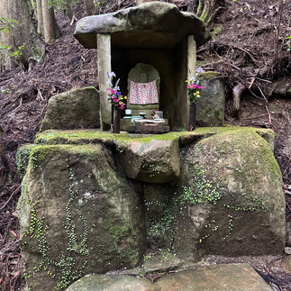
After about 3 miles I entered a forested area that was lush and green and began uphill towards the first mountain pass of the day. Shortly thereafter there was a sign for a turn off for the Kumasegawa-Oji. I was fighting time and this was not a place for a stamp, but I started up the path to see if it was nearby and visible. The path wasn’t great so I turned around and decided to give it a miss. About 50 yards later on there was a cemetery that I took to be the milepost listed on the map, but then there was another turn off for the prior Oji, so I tried again and found it this time.


Returning to the route I finally found the mile post sign I was looking for and continued my ascent to the Waraji-toge Pass. This was pleasant woodland and it was at the top of this pass where pilgrims would change their Warajis (straw sandals) before continuing.


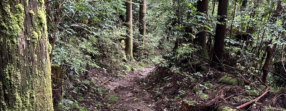
From there I descended to a logging road and the start of the detour.


This was also the start of the second, and highest, mountain pass of the day called the “detour pass”. I was a long uphill slog, some of which was quite steep. The worst thing was a combination of horse flies and a waspy-type of insect that were both about an inch long and tormented me on each uphill of the day. I’m amazed I didn’t have an accident because each time I heard their buzz I started to swat at them with my hiking poles, sometimes in rather dangerous areas, like on a slippery bridge.


There was one place where I almost got lost because I couldn’t figure out there was a “netted gate” I was supposed to go through, so I almost went the wrong way. Another reason I have backup planning tools I use when I’m on my own. In this case I had the route on All Trails.


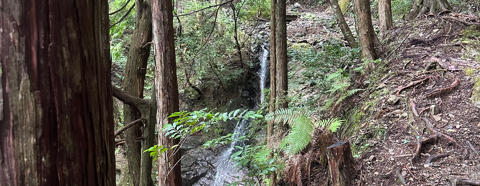
Anyway, I finally made it to the top of the pass (671 M or 2200 feet) and a glorious breeze come up. This is the Iwagami-toge Pass.


The terrain changes a bit at the bottom of the descent where it is flat in the river valley and I came upon various areas (here and a bit further on) where settlements have been abandoned, either hundreds of years ago and they were found through excavation, or as recent as the 1940s and the inhabitants were re-settled.
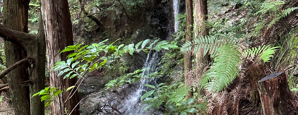
This river valley continued for several miles and with the sun out, walking along the wooded pathway, it was very pleasant.


It was at this point that the last rather steep uphill of the day occurred which brought me up to the Hosshinmon-Oji. This is one of the 5 most important oji. It means gate of spiritual awakening and marks the boundary of the sacred area of Hongu Taisha. It was about 11:3 at this point and I was 11 miles along and making reasonable time to catch my bus. It was time to take a well-deserved breakfast/lunch break. I shared part of it with one of the waspy things and, strangely, they bothered me less from this point on.


It was noon and I had about 4 miles to go, so I would make even an earlier bus - the 3:05!
Now I descended past small farms that were going tea and fruit and started to reach places where I could see views of my destination.


Fushiogami-Oji means “kneel down and pray”. This is where pilgrims have their first view of Hongu and it is also associated with the 10-th century female poet who was instrumental in having the kumano Kodo opened to female pilgrims. Women were considered unclean, so not allowed to make the pilgrimages.


There was a bridge to an old tea house and some more fungi


Between Waymarks 73 and 74 is a phenomenal view of the Torii gate of Hongu.


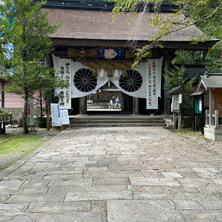
At just about 2pm I was descending past a Buddhist cemetery and Hongu Taisha was right in front of me. I walked through the torii gate and got my final stamp!


Here are some photos of the actual Hongu Taisha Shrine


I was very happy to get a mango flavored ice cream cone to celebrate and waited for the bus. It felt so good to sit down.

The bus stop was in front of the information center which had the bus timetable


The bus ride was about 20 minutes to Yunomine Onsen and stopped right out in front of the Ademaya Inn which was my place for these 2 nights (tomorrow being a day off). Here is my room and I even had my own Onsen bath in my room.

Right out my window you can see the entrance to the UNESCO site of Yunomine Bath. All the Inns here use the same water, so going to the public (or private ) bath in my hotel was the same as going to the “real” onsen. there was also a small enclosure next to the water where you can hard boil eggs and cook vegetables using the natural hot spring water.


Dinner was an amazing feast again and I went to bed really early.


Comments